Colorado is more than mountains and ski slopes?it is also a treasure trove of historic routes, vanished towns, and forgotten railways. One of the most rewarding ways to understand the state?s past is to explore it through old maps and atlases. For travelers who love history, road-tripping, and off-the-beaten-path adventures, historic Colorado maps can turn an ordinary visit into a true journey through time.
Why Historic Maps Matter for Travelers in Colorado
Modern navigation apps show the fastest way from point A to point B. Historic maps of Colorado, however, reveal why people traveled, where they settled, and how the landscape shaped their lives. By layering the past over the present, you can discover ghost towns, original wagon routes, early mining camps, and long-gone rail lines that once connected remote corners of the state.
Using historic maps while you travel helps you:
- Identify former town sites now reduced to foundations or cemeteries
- Trace early mining and ranching corridors through the Rockies
- Understand how rivers, canyons, and passes controlled movement and settlement
- Plan themed road trips following old stagecoach and rail routes
Key Regions of Colorado to Explore With Old Maps
Whether you are interested in mining history, frontier forts, or agricultural settlements on the plains, different regions of Colorado come alive when viewed through historic cartography.
The Colorado Plains: Vanished Towns and Railroad Lines
Eastern Colorado?s wide-open plains host a surprising number of forgotten townsites and re-routed railroads. Old county and railroad maps show names that no longer appear on modern maps?tiny whistle stops, postal hamlets, and farming communities that rose and fell with the fortunes of the rails and the harvests.
Travelers driving across the plains can use historic maps to:
- Locate former depots and sidings along long-straight rail corridors
- Find remnants of early irrigation canals and ditches that shaped farming
- Visit remaining grain elevators and town squares that still echo the old layouts
The Front Range: Early Cities and Evolving Street Grids
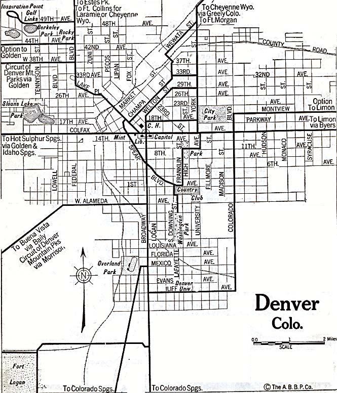
The Front Range corridor?home to Colorado?s major cities?looks very different on 19th? and early 20th?century maps. Early plats of towns along the base of the Rockies reveal original street grids, industrial zones, and transportation spurs that defined how people moved and worked.
With historic city and county maps in hand, visitors can:
- Walk downtown districts following original street layouts and early business blocks
- Compare old street names and alignments to today?s urban grid
- Identify historic rail yards, depots, and warehouse zones now repurposed as cultural hubs
The Colorado Rockies: Mining Camps and Mountain Passes
Colorado?s mountain regions may be the most dramatic to re?explore via historic maps. Mining rushes created hundreds of camps, prospecting roads, and narrow?gauge railways that clung to steep valley walls. Many of these appear clearly on old maps but have nearly vanished on the ground.
Using historic topographic and mining maps, travelers can:
- Track former wagon and rail routes over high passes and through narrow canyons
- Locate ghost towns, forgotten cemeteries, and abandoned mills
- Plan scenic drives that follow the general path of old prospecting roads
Types of Historic Colorado Maps Useful to Visitors
Not all old maps are equally helpful for travel, but several categories are especially rich for modern explorers.
County and Township Maps
County maps show early town boundaries, rural road networks, and land divisions. For travelers, they are perfect for:
- Understanding how settlements clustered around water sources and railroads
- Finding early schools, churches, and cemeteries that can still be visited
- Tracing original county lines and road patterns before modern highways
Railroad and Stage Route Maps
Rail and stage lines were the lifeblood of early Colorado travel. Historic transportation maps reveal:
- Key junctions where travelers once changed trains or coaches
- Mountain passes opened by rail and stage companies
- Small communities that sprang up solely to serve travelers and freight
Following these historic corridors by car today lets you parallel the journeys of 19th?century visitors, but with far more comfort and far fewer delays.
Plat Maps and Town Plans
Plat maps focus on specific communities, showing blocks, lots, and public spaces. They help you:
- Reconstruct the original layout of downtown districts and residential quarters
- Identify where early hotels, depots, and public buildings once stood
- Design walking tours that highlight how a town has grown, shifted, or contracted
Topographic and Geological Maps
For hikers and scenic?drive enthusiasts, historic topographic and geological maps are a bridge between natural landscapes and human activity. They show:
- Original trail systems, wagon roads, and mining access routes
- Locations of early mines, quarries, and smelters
- Geological formations that influenced where resources were extracted
Planning a Colorado Road Trip Around Historic Maps
Instead of simply driving between well?known tourist spots, consider designing a trip that follows the routes on historic maps of Colorado. This turns your journey into a rolling historical investigation.
Step 1: Choose a Theme
Pick a unifying theme that interests you and then select historic maps that highlight it. For example:
- Mining Heritage Loop: Focus on old mining districts, mills, and ghost towns.
- Railway Corridor Tour: Follow a former narrow?gauge route or mainline across the state.
- Frontier Plains Trail: Trace wagon routes and stage roads that once crossed the eastern plains.
Step 2: Align Old and New Maps
Once you have your historic maps, match them to modern road maps or digital navigation. Many old routes approximate current highways or county roads, though curves, cutoffs, and pass choices may differ.
When planning:
- Mark key historic locations and compare them to present?day towns or landmarks
- Note where ghost towns lie off main roads, requiring short detours or hikes
- Check road conditions and seasonal closures, especially in mountain regions
Step 3: Add On?the?Ground Exploration
Combine driving with short walks or hikes to explore locations noted on the maps. Old cemeteries, townsites, and rail grades often require leaving the car behind for a closer look. Always respect private property and local regulations, and be prepared for changing weather in Colorado?s varied elevations.
Using Historic Maps to Enrich City Visits
Historic cartography is not only for rural or remote adventures. Colorado?s cities are also more interesting when you see them through old maps.
Self?Guided Historic Walking Tours
Print or save copies of old town plats alongside modern city maps. As you stroll historic districts, compare:
- Former street names and alignments with today?s signage
- Locations of early depots, markets, and public squares
- Blocks where early hotels and theaters once dominated the skyline
This approach lets you imagine how 19th?century travelers first encountered Colorado?s frontier towns, what routes they walked from depot to lodging, and how the city?s commercial heart has shifted over the decades.
Neighborhood Evolution and Urban Change
Old city maps often reveal industrial zones, rail spurs, and riverfront warehouses now transformed into residential or arts districts. As you explore, try to connect former uses?mills, smelters, factories?to today?s restaurants, museums, and galleries. The contrast between past function and present character adds depth to your city sightseeing.
Respecting Historic Sites Discovered Through Old Maps
Historic maps can lead you to sensitive locations: family burial grounds, archaeological sites, and fragile ghost towns. When visiting such places, responsible behavior is essential.
- Stay on existing paths and avoid disturbing foundations or artifacts
- Do not remove objects, even if they seem abandoned
- Be mindful of erosion and plant life, especially in arid or alpine environments
- Observe any posted rules and local guidance about site protection
Traveling with historic maps is about learning, not collecting. Leave the landscapes and ruins intact for future visitors and researchers.
Practical Tips for Traveling Colorado With Historic Maps
To make the most of your time?traveling journeys across Colorado, it helps to prepare a bit more than you might for a standard road trip.
Combining Digital and Paper Resources
Historic maps can be large, detailed, and sometimes faded. Consider:
- Printing key sections for the areas you plan to visit
- Saving high?resolution images on a tablet for zooming into fine details
- Using offline navigation apps in remote mountain and plains regions
In places where mobile signal is weak, paper maps?both modern and historic?remain your most reliable tools.
Seasonal and Safety Considerations
Many older routes shown on maps crossed passes or followed rivers that are challenging in winter or during spring runoff. Before attempting to retrace a route:
- Check current road and pass conditions
- Confirm whether your vehicle is suitable for gravel, mud, or steep grades
- Carry extra water, layers, and basic emergency supplies, especially in isolated areas
Blending Scenic and Historical Interests
Colorado?s landscapes are spectacular even without historical context, but maps tie scenery to stories. When you pause at a viewpoint or trailhead, ask how earlier travelers saw the same ridge or valley. Old maps often mark lookout points, toll gates, and way stations that line up with today?s scenic overlooks, creating a continuity of appreciation across generations.
Where to Use Historic Maps During Your Stay
While driving and hiking with historic maps is rewarding, they can also enrich quieter moments of your trip.
- Evenings in town: Spread out copies of old county or city maps and plan the next day?s itinerary, spotting sites you may have missed on typical guide lists.
- Museum visits: Bring or reference historic maps when exploring local exhibits to see how artifacts fit within broader regional routes.
- Caf? breaks: Compare old and new maps as you rest, matching the names on the page to the mountains or streets outside the window.
Turning Colorado Into a Living Atlas
Traveling Colorado with historic maps transforms the state into a living atlas. Instead of isolated attractions, you experience connected routes, communities, and landscapes shaped by generations of movement and settlement. Whether you are tracing rail lines across the plains, hunting for ghost towns in high valleys, or decoding city street grids, historic maps give your journey context and coherence.
For visitors who enjoy blending discovery, research, and adventure, Colorado becomes not just a destination on a modern map but a layered tapestry of routes and stories waiting to be traced mile by mile.