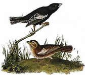
Colorado's State Bird is the Lark Bunting. Its common name is the Prairie-Lark Finch.
Welcome to the COGenWeb Project
Formation of the State of Colorado
Jefferson Territory was voted by the residents in 1859 but was never recognized by Congress. Because of this, some of the counties have organization dates and records prior to 28 February 1861 when the Territory of Colorado was finally recognized.
The first territorial assembly created the first seventeen counties in September 1861. These were Arapahoe, Boulder, Clear Creek, Costilla, Douglas, El Paso, Fremont, Gilpin, Guadalupe (later named Conejos), Huerfano, Jefferson, Lake, Larimer, Park, Pueblo, Summit and Weld.
On August 1, 1876 (28 days after the Centennial of the United States and 15 years after the territory was first formed), Colorado became the 38th state in the Union, earning it the nickname, "The Centennial State." Colorado is also known as "Colorful Colorado" and "The Heart of the Rockies."
The boundary lines of the state create an almost perfect rectangle, measuring approximately 387 miles from east to west and 276 miles from north to south and covering 104,247 square miles, including 450 square miles of bodies of water. Colorado is the eighth largest state when measured in square miles area.
More Colorado history here.
COGenWeb Resources:
In addition to our county sites, you will find a wealth of information right here. Begin your journey by checking out our "Site Directory" on the left sidebar or by going directly to our "Guide to Researching your Ancestors in Colorado" page. New information is added all the time, so please be sure to check back often.
Are you interested in adopting one of our available counties? Click here for a full list.
|
|
||
| Co-State Coordinator | Co-State Coordinator | |
|
Assist. Coordinator |
Assist. Coordinator | Webmistress |
| Michael Irwin |
|
|
||||||